
Photo Title
ABZ-22
Preview
Flight Code
ABZ
Date Flown
Spring 3-31-1964
Aerial Survey Project No. (A.S.P. No.)
61-117
County
Jackson
Trunk Highway (T.H.)
I-90
Location
Jct. TH I-90 and TH 71 N. of Jackson
Center Latitude
43°38'9.28"N
Center Longitude
95° 0'24.03"W
Scale
1’’=400’
Flight Height
2400
Notes
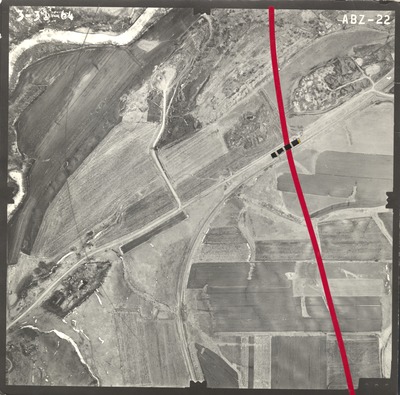
Notes on front include red tape used to show road construction plans and black dotted tape on existing road. Hand-drawn line with tick marks and crossing lines indicating principal point. Data includes "$ta. 1180" near black dotted tape and "top" written near a tick mark.
Work Order No.
0105
Agreement No.
52998
Statewide Project No.
62
State Project No.
3280
Focal Length
152.43 mm
Physical Format
Black and White Physical Aerial Photograph
Dimensions
9 x 9
Item Type
Still Image
Collection Name
Minnesota Department of Transportation District 7 Air Photo Collection, 1957-2006
Contributing Organization
Dr. Mary T. Dooley Map Library, Memorial Library, Minnesota State University, Mankato, P.O. Box 8419, Mankato, MN 56002-8419
Contact Information
Dr. Mary T. Dooley Map Library, Memorial Library, Minnesota State University, Mankato, P.O. Box 8419, Mankato, MN 56002-8419
Creative Commons License

This work is licensed under a Creative Commons Attribution-NonCommercial 4.0 International License
Scanning Center
Dr. Mary T. Dooley Map Library, Memorial Library, Minnesota State University, Mankato, P.O. Box 8419, Mankato, MN 56002-8419
Object File Name
MnDOT_1964_61-117_ABZ-22.tif
Date Digital
2021-04-16
Item Digital Format
Image/tiff
Master File Format
Image/tiff
Master File Size
104216178
Master File Bit Depth
24
Master File Resolution
800 dpi
Master File Width
7627
Master File Height
7533
Master File Hardware
Epson Expression 10000XL
Master File Software
VueScan
Master File System
Windows 10
Master File Checksum
6ad2e5b6934ccba8a6103399f95917f7
Keywords
mndot, air photos, aerial photography, 1964, des moines river, stream, railroad, gravel pit

