

Preview
Photographer
Mark Hurd Aerial Surveys, Inc. Minneapolis, Minnesota
Description
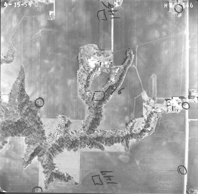
Aerial Photograph of the greater Mankato Area, Mankato, Minnesota from 1959
Flight Code
HXG
County Name
Blue Earth
Center Latitude
44° 8'22.98"N
Center Longitude
93°59'42.30"W
Date Flown
1959-04-15
Lens Serial Number
XF 6778
Scale
1/5000
Physical Format
Black and White Aerial Photograph
Dimensions
9 x 9
Item Type
Still Image
Collection Name
1959 Greater Mankato Area Air Photos (HXG)
Contributing Organization
Dr. Mary T. Dooley Map Library, Memorial Library, Minnesota State University, Mankato, P.O. Box 8419, Mankato, MN 56002-8419
Contact Information
Dr. Mary T. Dooley Map Library, Memorial Library, Minnesota State University, Mankato, P.O. Box 8419, Mankato, MN 56002-8419
Creative Commons License

This work is licensed under a Creative Commons Attribution-NonCommercial 4.0 International License
Notes
Notes on front include intersecting lines indicating the principal point, circles to rectify the image, and other points with data.
Scanning Center
Dr. Mary T. Dooley Map Library, Memorial Library, Minnesota State University, Mankato, P.O. Box 8419, Mankato, MN 56002-8419
Object File Name
GreaterMankato_1959_HXG-146a.tif
Date Digital
2021-11-05
Item Digital Format
Image/tiff
Master File Format
Image/tiff
Master File Size
104712105
Master File Bit Depth
16
Master File Resolution
800 dpi
Master File Width
7296
Master File Height
7174
Master File Hardware
Epson Expression 10000XL
Master File Software
VueScan
Master File System
Windows 10
Master File Checksum
10c53895b17cb80f6ee5760fb12990a9
Keywords
aerial photographs, air photos, Mankato, Minnesota, Blue Earth County, 1959

