

Preview
Creator
State Drainage Commission, St. Paul, Minnesota
Publisher
U.S. Geological Survey (Washington, D.C.)
Year(s) Surveyed
1911
Scale
1:24000
Coordinates
(W 91°58'27"-W 91°37'26"/N 47°55'05"-N 47°42'46")
Notes
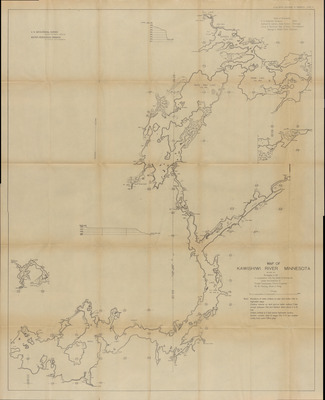
Printed note on map reads "Note: Elevations of water surface on plan and profile refer to highwater stage. Contour interval on land and on water surface 5 feet except between Fall and Garden lakes where it is 10 feet. Dotted contour is 5 feet below highwater surface. Section corners west of range line 11-12 are located chiefly from Land Office plats."
Description
1909-1912 Minnesota river maps and profiles from the Minnesota State Drainage Commission in cooperation with the USGS.
Physical Format
Map
Dimensions
111.7 x 90.3 cm
Item Type
Cartographic
Collection Name
Minnesota River Surveys, 1909-1912
Contributing Organization
Dr. Mary T. Dooley Map Library, Memorial Library, Minnesota State University, Mankato, P.O. Box 8419, Mankato, MN 56002-8419
Contact Information
Dr. Mary T. Dooley Map Library, Memorial Library, Minnesota State University, Mankato, P.O. Box 8419, Mankato, MN 56002-8419
Creative Commons License

This work is licensed under a Creative Commons Attribution-NonCommercial 4.0 International License
Scanning Center
Dr. Mary T. Dooley Map Library, Memorial Library, Minnesota State University, Mankato, P.O. Box 8419, Mankato, MN 56002-8419
Object File Name
MNRiverSurveys_Vol2_Plate31KawishiwiRiverSheet1.tif
Date Digital
2025-02-26
Item Digital Format
Image/tiff
Master File Format
Image/tiff
Master File Size
1727441816
Master File Bit Depth
24
Master File Resolution
600 dpi
Master File Width
21613
Master File Height
26628
Master File Hardware
Zeutschel OS C1
Master File Software
OmniScan Software OS12
Master File System
Windows 11
Master File Checksum
2936636808b9737c8d70483ad372f040
Keywords
mn river surveys, minnesota state drainage commission, usgs, maps, 1911, kawishiwi river

