

Preview
Flight Code
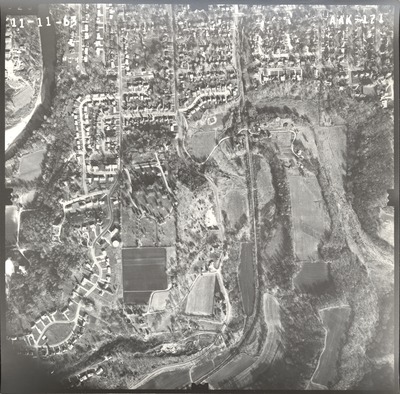
AAK
Date Flown
Fall 11-11-1963
Aerial Survey Project No. (A.S.P. No.)
61-79
County
Blue Earth
Trunk Highway (T.H.)
66
Location
Between Rapidan and Mankato
Center Latitude
44° 8'45.12"N
Center Longitude
94° 1'29.88"W
Scale
1''=500'
Flight Height
3000
Work Order No.
66
Agreement No.
52998
Statewide Project No.
62
State Project No.
0715
Focal Length
152.43 mm
Physical Format
Black and White Physical Aerial Photograph
Dimensions
9 x 9
Item Type
Still Image
Collection Name
Minnesota Department of Transportation District 7 Air Photo Collection, 1957-2006
Contributing Organization
Dr. Mary T. Dooley Map Library, Memorial Library, Minnesota State University, Mankato, P.O. Box 8419, Mankato, MN 56002-8419
Contact Information
Dr. Mary T. Dooley Map Library, Memorial Library, Minnesota State University, Mankato, P.O. Box 8419, Mankato, MN 56002-8419
Creative Commons License

This work is licensed under a Creative Commons Attribution-NonCommercial 4.0 International License
Scanning Center
Dr. Mary T. Dooley Map Library, Memorial Library, Minnesota State University, Mankato, P.O. Box 8419, Mankato, MN 56002-8419
Object File Name
MnDOT_1963_61-79_AAK-171.tif
Date Digital
2021-02-16
Item Digital Format
Image/tiff
Master File Format
Image/tiff
Master File Size
118829244
Master File Bit Depth
24
Master File Resolution
800 dpi
Master File Width
7504
Master File Height
7383
Master File Hardware
Epson Expression 10000XL
Master File Software
VueScan
Master File System
Windows 10
Master File Checksum
60b73519fd39cba29512ac5bc6afc0b2
Keywords
mndot, air photos, aerial photography, 1963, mankato, blue earth river, railroad, grand view memorial cemetery

