

Preview
Flight Code
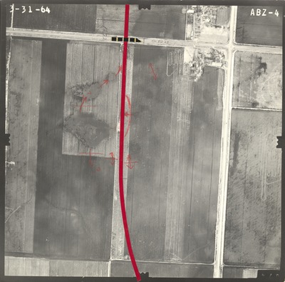
ABZ
Date Flown
Spring 3-31-1964
Aerial Survey Project No. (A.S.P. No.)
61-117
County
Jackson
Trunk Highway (T.H.)
I-90
Location
Jct. TH I-90 and TH 71 N. of Jackson
Center Latitude
43°38'33.30"N
Center Longitude
94°58'10.12"W
Scale
1’’=400’
Flight Height
2400
Notes
Notes on front include red tape used to show road construction plans and black dotted tape on existing road. Handwritten data includes "1272, Co. Rd. 23, and $ta. 1300." Symbols include hand-drawn arrow for flow direction, ?s, and double arrows with lines in center.
Work Order No.
0105
Agreement No.
52998
Statewide Project No.
62
State Project No.
3280
Focal Length
152.43 mm
Physical Format
Black and White Physical Aerial Photograph
Dimensions
9 x 9
Item Type
Still Image
Collection Name
Minnesota Department of Transportation District 7 Air Photo Collection, 1957-2006
Contributing Organization
Dr. Mary T. Dooley Map Library, Memorial Library, Minnesota State University, Mankato, P.O. Box 8419, Mankato, MN 56002-8419
Contact Information
Dr. Mary T. Dooley Map Library, Memorial Library, Minnesota State University, Mankato, P.O. Box 8419, Mankato, MN 56002-8419
Creative Commons License

This work is licensed under a Creative Commons Attribution-NonCommercial 4.0 International License
Scanning Center
Dr. Mary T. Dooley Map Library, Memorial Library, Minnesota State University, Mankato, P.O. Box 8419, Mankato, MN 56002-8419
Object File Name
MnDOT_1964_61-117_ABZ-4a.tif
Date Digital
2021-04-16
Item Digital Format
Image/tiff
Master File Format
Image/tiff
Master File Size
101407976
Master File Bit Depth
24
Master File Resolution
800 dpi
Master File Width
7584
Master File Height
7491
Master File Hardware
Epson Expression 10000XL
Master File Software
VueScan
Master File System
Windows 10
Master File Checksum
831d9573f408b94aa715aa62286ed468
Keywords
mndot, air photos, aerial photography, 1964, drainage design

