

Preview
Flight Code
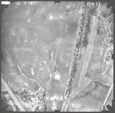
FEN
Date Flown
Fall 11-9-1978
Aerial Survey Project No. (A.S.P. No.)
78F-39
County
Le Sueur
Trunk Highway (T.H.)
60
Location
Bridge 5467 TH 60 over Chicago and North Western Railway in Waterville
Center Latitude
44°12'25.05"N
Center Longitude
93°34'52.94"W
Scale
1''=250'
Flight Height
1500
Work Order No.
19
Agreement No.
59194
State Project No.
4006-29
Lens Serial Number
98193
Focal Length
152.46 mm
Physical Format
Black and White Physical Aerial Photograph
Dimensions
9 x 9
Item Type
Still Image
Collection Name
Minnesota Department of Transportation District 7 Air Photo Collection, 1957-2006
Contributing Organization
Dr. Mary T. Dooley Map Library, Memorial Library, Minnesota State University, Mankato, P.O. Box 8419, Mankato, MN 56002-8419
Contact Information
Dr. Mary T. Dooley Map Library, Memorial Library, Minnesota State University, Mankato, P.O. Box 8419, Mankato, MN 56002-8419
Creative Commons License

This work is licensed under a Creative Commons Attribution-NonCommercial 4.0 International License
Scanning Center
Dr. Mary T. Dooley Map Library, Memorial Library, Minnesota State University, Mankato, P.O. Box 8419, Mankato, MN 56002-8419
Object File Name
MnDOT_1978_78F-39_FEN-12.tif
Date Digital
2022-07-22
Item Digital Format
Image/tiff
Master File Format
Image/tiff
Master File Size
105044702
Master File Bit Depth
24
Master File Resolution
800 dpi
Master File Width
7579
Master File Height
7444
Master File Hardware
Epson Expression 10000XL
Master File Software
VueScan
Master File System
Windows 10
Master File Checksum
29a4916ecd115369d7f10df8c4b3742d
Keywords
mndot, air photos, aerial photography, 1978, white water creek, railroad, junkyard, marsh

