

Preview
Flight Code
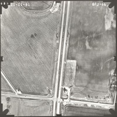
GFJ
Date Flown
Fall 11-11-1981
Aerial Survey Project No. (A.S.P. No.)
81F-24
County
Le Sueur, Scott
Trunk Highway (T.H.)
169
Location
Bridge 9295 over Minnesota River near Le Sueur to Jct. TH 169 and TH 19 N.E. of Le Sueur
Center Latitude
44°32'42.59"N
Center Longitude
93°50'58.80"W
Scale
1''=250'
Flight Height
1500
Notes
Notes on front include hand-drawn lines.
Work Order No.
12
Agreement No.
60576
State Project No.
4013
Lens Serial Number
124302
Focal Length
152.963 mm
Physical Format
Black and White Physical Aerial Photograph
Dimensions
9 x 9
Item Type
Still Image
Collection Name
Minnesota Department of Transportation District 7 Air Photo Collection, 1957-2006
Contributing Organization
Dr. Mary T. Dooley Map Library, Memorial Library, Minnesota State University, Mankato, P.O. Box 8419, Mankato, MN 56002-8419
Contact Information
Dr. Mary T. Dooley Map Library, Memorial Library, Minnesota State University, Mankato, P.O. Box 8419, Mankato, MN 56002-8419
Creative Commons License

This work is licensed under a Creative Commons Attribution-NonCommercial 4.0 International License
Scanning Center
Dr. Mary T. Dooley Map Library, Memorial Library, Minnesota State University, Mankato, P.O. Box 8419, Mankato, MN 56002-8419
Object File Name
MnDOT_1981_81F-24_GFJ-66.tif
Date Digital
2022-11-30
Item Digital Format
Image/tiff
Master File Format
Image/tiff
Master File Size
121743316
Master File Bit Depth
24
Master File Resolution
800 dpi
Master File Width
7360
Master File Height
7363
Master File Hardware
Epson Expression 10000XL
Master File Software
VueScan
Master File System
Windows 10
Master File Checksum
8b592a03a28e6570afbfd8a0d0c56907
Keywords
mndot, air photos, aerial photography, 1981, stream

