

Preview
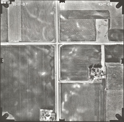
Flight Code
KHT
Date Flown
Fall 11-11-1987
Aerial Survey Project No. (A.S.P. No.)
87F-63
County
Faribault
Trunk Highway (T.H.)
253
Location
From Bricelyn to I-90
Center Latitude
43°36'52.17"N
Center Longitude
93°48'26.79"W
Scale
1’’=400’
Flight Height
2400
Work Order No.
18
Agreement No.
64236
State Project No.
2210-11
Focal Length
152.953 mm
Physical Format
Black and White Physical Aerial Photograph
Dimensions
9 x 9
Item Type
Still Image
Collection Name
Minnesota Department of Transportation District 7 Air Photo Collection, 1957-2006
Contributing Organization
Dr. Mary T. Dooley Map Library, Memorial Library, Minnesota State University, Mankato, P.O. Box 8419, Mankato, MN 56002-8419
Contact Information
Dr. Mary T. Dooley Map Library, Memorial Library, Minnesota State University, Mankato, P.O. Box 8419, Mankato, MN 56002-8419
Creative Commons License

This work is licensed under a Creative Commons Attribution-NonCommercial 4.0 International License
Scanning Center
Dr. Mary T. Dooley Map Library, Memorial Library, Minnesota State University, Mankato, P.O. Box 8419, Mankato, MN 56002-8419
Object File Name
MnDOT_1987_87F-63_KHT-14.tif
Date Digital
2023-04-14
Item Digital Format
Image/tiff
Master File Format
Image/tiff
Master File Size
98351450
Master File Bit Depth
24
Master File Resolution
800 dpi
Master File Width
7432
Master File Height
7309
Master File Hardware
Epson Expression 10000XL
Master File Software
VueScan
Master File System
Windows 10
Master File Checksum
460776119a14ad916ebe2db9dccaaf11
Keywords
mndot, air photos, aerial photography, 1987, field tiling

