

Preview
Date Flown
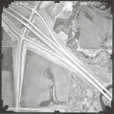
Spring 4-5-1992
Aerial Survey Project No. (A.S.P. No.)
92S-67
County
Watonwan
Trunk Highway (T.H.)
60
Location
Madelia Maintenance Site
Center Latitude
44° 2'18.96"N
Center Longitude
94°24'48.96"W
Scale
1''=250'
Flight Height
1500
Work Order No.
55
Agreement No.
67546
State Project No.
8310
Camera
Zeiss RMK-A 15/23 W/FMC
Lens Serial Number
137516
Focal Length
153.58 mm
Physical Format
Black and White Physical Aerial Photograph
Dimensions
9 x 9
Item Type
Still Image
Collection Name
Minnesota Department of Transportation District 7 Air Photo Collection, 1957-2006
Contributing Organization
Dr. Mary T. Dooley Map Library, Memorial Library, Minnesota State University, Mankato, P.O. Box 8419, Mankato, MN 56002-8419
Contact Information
Dr. Mary T. Dooley Map Library, Memorial Library, Minnesota State University, Mankato, P.O. Box 8419, Mankato, MN 56002-8419
Creative Commons License

This work is licensed under a Creative Commons Attribution-NonCommercial 4.0 International License
Scanning Center
Dr. Mary T. Dooley Map Library, Memorial Library, Minnesota State University, Mankato, P.O. Box 8419, Mankato, MN 56002-8419
Object File Name
MnDOT_1992_92S-67-6.tif
Date Digital
2023-10-06
Item Digital Format
Image/tiff
Master File Format
Image/tiff
Master File Size
106968524
Master File Bit Depth
24
Master File Resolution
800 dpi
Master File Width
7464
Master File Height
7449
Master File Hardware
Epson Expression 10000XL
Master File Software
VueScan
Master File System
Windows 10
Master File Checksum
d8cda4ea6cb81b4636a6a9056d0e107b
Keywords
mndot, air photos, aerial photography, 1992, watonwan river, marsh, field tiling, possible dump site, wetland

