

Preview
Date Flown
Spring 4-5-1992
Aerial Survey Project No. (A.S.P. No.)
92S-84
County
Blue Earth
Trunk Highway (T.H.)
14
Location
Mankato Bypass Extension
Center Latitude
44°10'34.93"N
Center Longitude
93°54'59.55"W
Scale
1''=500'
Flight Height
3000
Notes
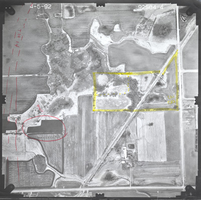
Notes on front include a hand-drawn yellow outlined area, red oval, and proposed road design. Notes read "TH 14" and "Trail."
Work Order No.
70
Agreement No.
67546
State Project No.
0702-87
Camera
Zeiss RMK-A 15/23 W/FMC
Lens Serial Number
137516
Focal Length
153.58 mm
Physical Format
Black and White Physical Aerial Photograph
Dimensions
9 x 9
Item Type
Still Image
Collection Name
Minnesota Department of Transportation District 7 Air Photo Collection, 1957-2006
Contributing Organization
Dr. Mary T. Dooley Map Library, Memorial Library, Minnesota State University, Mankato, P.O. Box 8419, Mankato, MN 56002-8419
Contact Information
Dr. Mary T. Dooley Map Library, Memorial Library, Minnesota State University, Mankato, P.O. Box 8419, Mankato, MN 56002-8419
Creative Commons License

This work is licensed under a Creative Commons Attribution-NonCommercial 4.0 International License
Scanning Center
Dr. Mary T. Dooley Map Library, Memorial Library, Minnesota State University, Mankato, P.O. Box 8419, Mankato, MN 56002-8419
Object File Name
MnDOT_1992_92S-84-4.tif
Date Digital
2023-10-17
Item Digital Format
Image/tiff
Master File Format
Image/tiff
Master File Size
95559404
Master File Bit Depth
24
Master File Resolution
800 dpi
Master File Width
7560
Master File Height
7494
Master File Hardware
Epson Expression 12000XL
Master File Software
VueScan
Master File System
Windows 10
Master File Checksum
5ea2ff42fde422f25aa5cde3002d1ea4
Keywords
mndot, air photos, aerial photography, 1992, lime siding, pond, stream, marsh, railroad, field tiling, wetland

