

Preview
Date Flown
Spring 4-17-1993
Aerial Survey Project No. (A.S.P. No.)
93S-41
County
Sibley
Trunk Highway (T.H.)
93
Location
N. Jct TH 169 to Henderson
Center Latitude
44°30'2.35"N
Center Longitude
93°54'17.28"W
Scale
1"=250'
Flight Height
1500
Notes
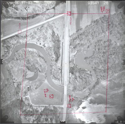
Note on front reads "21029 TRI" with hand-drawn red square with a "T" inside. Other notes read "06020 Tgt" and "06027 Tgt" with hand-drawn red squares with triangles inside identifying reference points located on the ground. Other notes read "21028" with hand-drawn red square with a dot inside. There is also a note that reads "06029" with a hand-drawn red square with a triangle and circle inside identifying a reference point. There is a hand-drawn red outline of an area.
Work Order No.
19
Agreement No.
69831
State Project No.
7212
Camera
Zeiss RMK-A 15/23 W/FMC
Lens Serial Number
137516
Focal Length
153.57 mm
Physical Format
Black and White Physical Aerial Photograph
Dimensions
9 x 9
Item Type
Still Image
Collection Name
Minnesota Department of Transportation District 7 Air Photo Collection, 1957-2006
Contributing Organization
Dr. Mary T. Dooley Map Library, Memorial Library, Minnesota State University, Mankato, P.O. Box 8419, Mankato, MN 56002-8419
Contact Information
Dr. Mary T. Dooley Map Library, Memorial Library, Minnesota State University, Mankato, P.O. Box 8419, Mankato, MN 56002-8419
Creative Commons License

This work is licensed under a Creative Commons Attribution-NonCommercial 4.0 International License
Scanning Center
Dr. Mary T. Dooley Map Library, Memorial Library, Minnesota State University, Mankato, P.O. Box 8419, Mankato, MN 56002-8419
Object File Name
MnDOT_1993_93S-41-28.tif
Date Digital
2023-10-24
Item Digital Format
Image/tiff
Master File Format
Image/tiff
Master File Size
92588374
Master File Bit Depth
24
Master File Resolution
800 dpi
Master File Width
7376
Master File Height
7327
Master File Hardware
Epson Expression 12000XL
Master File Software
VueScan
Master File System
Windows 10
Master File Checksum
903460d230bb66b9d14e8a3efb7cece9
Keywords
mndot, air photos, aerial photography, 1993, minnesota river, rush river, pond, field tiling, wetland

