

Preview
Date Flown
Spring 4-22-1993
Aerial Survey Project No. (A.S.P. No.)
93S-43
County
Sibley
Trunk Highway (T.H.)
19
Location
Gibbon
Center Latitude
44°32'5.41"N
Center Longitude
94°31'44.38"W
Scale
1"=250'
Flight Height
1500
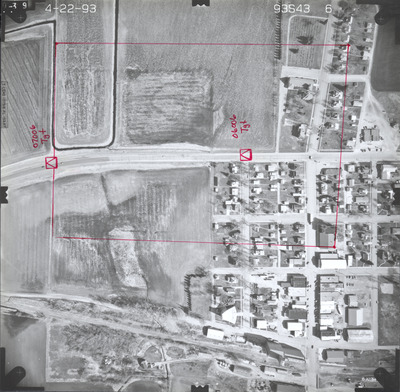
Notes
Notes on front read "07006 Tgt" and "06006 Tgt" with hand-drawn red squares with triangles inside identifying the reference points located on the ground. There is also a hand-drawn red outline of an area.
Work Order No.
19
Agreement No.
69831
State Project No.
7204-16
Camera
Zeiss RMK-A 15/23 W/FMC
Lens Serial Number
137516
Focal Length
153.57 mm
Physical Format
Black and White Physical Aerial Photograph
Dimensions
9 x 9
Item Type
Still Image
Collection Name
Minnesota Department of Transportation District 7 Air Photo Collection, 1957-2006
Contributing Organization
Dr. Mary T. Dooley Map Library, Memorial Library, Minnesota State University, Mankato, P.O. Box 8419, Mankato, MN 56002-8419
Contact Information
Dr. Mary T. Dooley Map Library, Memorial Library, Minnesota State University, Mankato, P.O. Box 8419, Mankato, MN 56002-8419
Creative Commons License

This work is licensed under a Creative Commons Attribution-NonCommercial 4.0 International License
Scanning Center
Dr. Mary T. Dooley Map Library, Memorial Library, Minnesota State University, Mankato, P.O. Box 8419, Mankato, MN 56002-8419
Object File Name
MnDOT_1993_93S-43-6a.tif
Date Digital
2023-10-25
Item Digital Format
Image/tiff
Master File Format
Image/tiff
Master File Size
90910224
Master File Bit Depth
24
Master File Resolution
800 dpi
Master File Width
7384
Master File Height
7241
Master File Hardware
Epson Expression 12000XL
Master File Software
VueScan
Master File System
Windows 10
Master File Checksum
f12de9153d03aa451befe6a8f684a47b
Keywords
mndot, air photos, aerial photography, 1993, gibbon, ditch, stream, railroad, field tiling, grain elevator, immanuel lutheran cemetery

