

Preview
Date Flown
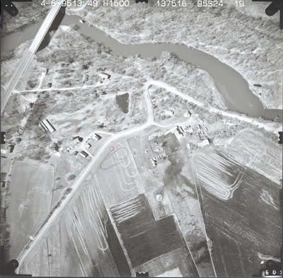
Spring 4-6-1995
Aerial Survey Project No. (A.S.P. No.)
95S-24
County
Brown
Trunk Highway (T.H.)
15
Location
New Ulm
Center Latitude
44°16'52.31"N
Center Longitude
94°25'52.20"W
Scale
1''=250'
Flight Height
1500
Notes
Note on front includes a hand-drawn red circle identifying the reference point located on the ground.
Work Order No.
20
Agreement No.
72206
State Project No.
0805-55
Camera
Zeiss RMK-A 15/23 W/FMC
Lens Serial Number
137516
Focal Length
153.58 mm
Physical Format
Black and White Physical Aerial Photograph
Dimensions
9 x 9
Item Type
Still Image
Collection Name
Minnesota Department of Transportation District 7 Air Photo Collection, 1957-2006
Contributing Organization
Dr. Mary T. Dooley Map Library, Memorial Library, Minnesota State University, Mankato, P.O. Box 8419, Mankato, MN 56002-8419
Contact Information
Dr. Mary T. Dooley Map Library, Memorial Library, Minnesota State University, Mankato, P.O. Box 8419, Mankato, MN 56002-8419
Creative Commons License

This work is licensed under a Creative Commons Attribution-NonCommercial 4.0 International License
Scanning Center
Dr. Mary T. Dooley Map Library, Memorial Library, Minnesota State University, Mankato, P.O. Box 8419, Mankato, MN 56002-8419
Object File Name
MnDOT_1995_95S-24-19.tif
Date Digital
2023-11-08
Item Digital Format
Image/tiff
Master File Format
Image/tiff
Master File Size
93499368
Master File Bit Depth
24
Master File Resolution
800 dpi
Master File Width
7360
Master File Height
7225
Master File Hardware
Epson Expression 12000XL
Master File Software
VueScan
Master File System
Windows 10
Master File Checksum
de5c6f833db1b014f021a1c4e7b5c280
Keywords
mndot, air photos, aerial photography, 1995, new ulm, cottonwood river, pond, field tiling, wetland

