

Preview
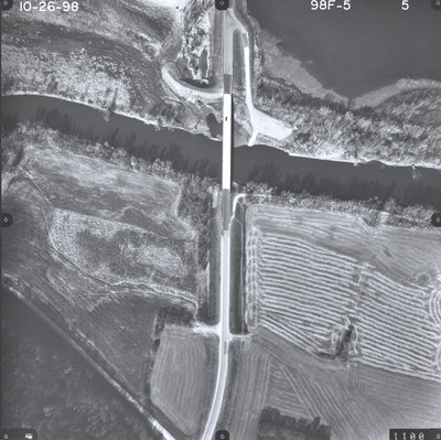
Date Flown
Fall 10-26-1998
Aerial Survey Project No. (A.S.P. No.)
98F-5
County
Brown, Nicollet
Trunk Highway (T.H.)
4
Location
Bridge over Minnesota River
Center Latitude
44°25'58.12"N
Center Longitude
94°43'1.00"W
Scale
1''=250'
Flight Height
1500
Work Order No.
4
Agreement No.
77624
State Project No.
0802, 5201
Camera
Zeiss RMK Top 15 W/FMC and Gyro Mount
Lens Serial Number
145851
Focal Length
153.123 mm
Physical Format
Black and White Physical Aerial Photograph
Dimensions
9 x 9
Item Type
Still Image
Collection Name
Minnesota Department of Transportation District 7 Air Photo Collection, 1957-2006
Contributing Organization
Dr. Mary T. Dooley Map Library, Memorial Library, Minnesota State University, Mankato, P.O. Box 8419, Mankato, MN 56002-8419
Contact Information
Dr. Mary T. Dooley Map Library, Memorial Library, Minnesota State University, Mankato, P.O. Box 8419, Mankato, MN 56002-8419
Creative Commons License

This work is licensed under a Creative Commons Attribution-NonCommercial 4.0 International License
Scanning Center
Dr. Mary T. Dooley Map Library, Memorial Library, Minnesota State University, Mankato, P.O. Box 8419, Mankato, MN 56002-8419
Object File Name
MnDOT_1998_98F-5-5.tif
Date Digital
2023-12-04
Item Digital Format
Image/tiff
Master File Format
Image/tiff
Master File Size
106256298
Master File Bit Depth
24
Master File Resolution
800 dpi
Master File Width
7240
Master File Height
7222
Master File Hardware
Epson Expression 12000XL
Master File Software
VueScan
Master File System
Windows 10
Master File Checksum
892aaa7cc8f06202fc4d0c8814336529
Keywords
mndot, air photos, aerial photography, 1998, minnesota river, pond, field tiling, wetland

