

Preview
Date Flown
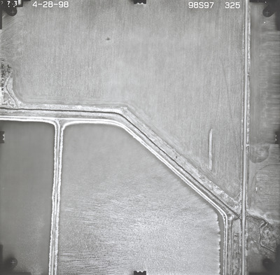
Spring 4-28-1998
Aerial Survey Project No. (A.S.P. No.)
98S-97
County
Nobles
Trunk Highway (T.H.)
60
Location
Iowa border to I-90 at Worthington
Center Latitude
43°38'57.74"N
Center Longitude
95°32'9.15"W
Scale
1''=250'
Flight Height
1500
Work Order No.
66
Agreement No.
75157
State Project No.
5305
Camera
Zeiss RMK-A 15/23 W/FMC
Lens Serial Number
137516
Focal Length
153.580 mm
Physical Format
Black and White Physical Aerial Photograph
Dimensions
9 x 9
Item Type
Still Image
Collection Name
Minnesota Department of Transportation District 7 Air Photo Collection, 1957-2006
Contributing Organization
Dr. Mary T. Dooley Map Library, Memorial Library, Minnesota State University, Mankato, P.O. Box 8419, Mankato, MN 56002-8419
Contact Information
Dr. Mary T. Dooley Map Library, Memorial Library, Minnesota State University, Mankato, P.O. Box 8419, Mankato, MN 56002-8419
Creative Commons License

This work is licensed under a Creative Commons Attribution-NonCommercial 4.0 International License
Scanning Center
Dr. Mary T. Dooley Map Library, Memorial Library, Minnesota State University, Mankato, P.O. Box 8419, Mankato, MN 56002-8419
Object File Name
MnDOT_1998_98S-97-325.tif
Date Digital
2022-07-12
Item Digital Format
Image/tiff
Master File Format
Image/tiff
Master File Size
99504482
Master File Bit Depth
24
Master File Resolution
800 dpi
Master File Width
7328
Master File Height
7202
Master File Hardware
Epson Expression 10000XL
Master File Software
VueScan
Master File System
Windows 10
Master File Checksum
1c95391bbb4ff075e39ecfec130653ce
Keywords
mndot, air photos, aerial photography, 1998, okabena creek, sewage disposal pond, field tiling

