

Preview
Date Flown
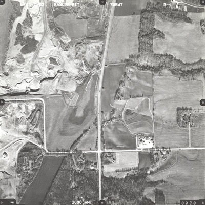
Fall 11-6-2003
Job No.
70847
County
Le Sueur
Location
Kasota Pit
Description
2003 aerial photography of James Pit, Cambria Pit, and Kasota Pit commissioned by Blue Earth County Public Works.
Center Latitude
44.271675
Center Longitude
-93.959044
Scale
1''=500'
Flight Height
3000
Camera
Zeiss RMK Top 15
Camera Serial Number
145848
Lens Serial Number
[145897]
Focal Length
153.433 mm
Frame Orientation
Vertical
Physical Format
Black and White Physical Aerial Photograph
Dimensions
9 x 9
Item Type
Still Image
Collection Name
Blue Earth County Public Works Air Photo Collection
Contributing Organization
Dr. Mary T. Dooley Map Library, Memorial Library, Minnesota State University, Mankato, P.O. Box 8419, Mankato, MN 56002-8419
Contact Information
Dr. Mary T. Dooley Map Library, Memorial Library, Minnesota State University, Mankato, P.O. Box 8419, Mankato, MN 56002-8419
Creative Commons License

This work is licensed under a Creative Commons Attribution-NonCommercial 4.0 International License
Scanning Center
Dr. Mary T. Dooley Map Library, Memorial Library, Minnesota State University, Mankato, P.O. Box 8419, Mankato, MN 56002-8419
Object File Name
BECPW_2003_70847_3-01.tif
Date Digital
2026-04-01
Item Digital Format
Image/tiff
Master File Format
Image/tiff
Master File Size
116173654
Master File Bit Depth
24
Master File Resolution
800 dpi
Master File Width
7232
Master File Height
7235
Master File Hardware
Epson Expression 12000XL
Master File Software
VueScan
Master File System
Windows 11
Master File Checksum
931ddecfdada8a077487235f4a26973d
Keywords
blue earth county public works, air photos, aerial photography, 2003, pond, stream, field tiling, gravel pit, wetland

