

Preview
Flight Code
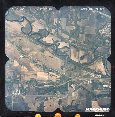
CN
Date Flown
Spring 5-7-1992
Project No.
920104
County
Blue Earth, Nicollet
Center Latitude
44° 9'41.10"N
Center Longitude
94° 5'25.62"W
Scale
1:40000
Flight Height
20000
Camera
Camera No. 244665A
Focal Length
151.586 mm
Physical Format
Color Physical Aerial Photograph
Dimensions
9 x 9
Item Type
Still Image
Collection Name
1992 Minnesota Air Photos (CN)
Contributing Organization
Dr. Mary T. Dooley Map Library, Memorial Library, Minnesota State University, Mankato, P.O. Box 8419, Mankato, MN 56002-8419
Contact Information
Dr. Mary T. Dooley Map Library, Memorial Library, Minnesota State University, Mankato, P.O. Box 8419, Mankato, MN 56002-8419
Creative Commons License

This work is licensed under a Creative Commons Attribution-NonCommercial 4.0 International License
Scanning Center
Dr. Mary T. Dooley Map Library, Memorial Library, Minnesota State University, Mankato, P.O. Box 8419, Mankato, MN 56002-8419
Object File Name
USGS_NAPP_1992_CN-49.tif
Date Digital
2025-07-23
Item Digital Format
Image/tiff
Master File Format
Image/tiff
Master File Size
127671858
Master File Bit Depth
24
Master File Resolution
800 dpi
Master File Width
7840
Master File Height
7977
Master File Hardware
Epson Expression 12000XL
Master File Software
VueScan
Master File System
Windows 11
Master File Checksum
59b2abd02faf3c4bb6d879edae9d8142
Keywords
usgs, napp, air photos, aerial photography, 1992, north mankato, blue earth river, minnesota river, minneopa creek, pond, stream, railroad, golf course, gravel pit, tank farm, field tiling, minneopa cemetery, wetland


Description
Aerial photography of Blue Earth County, Le Sueur County, and Nicollet County from the 1992 National Aerial Photography Program coordinated by the USGS.